

 Travel Essentials
 Travel Essentials

Your comprehensive guide to visiting Guadalupe Mountains National Park, featuring trail recommendations, camping options, and practical planning tips.
 Travel Essentials
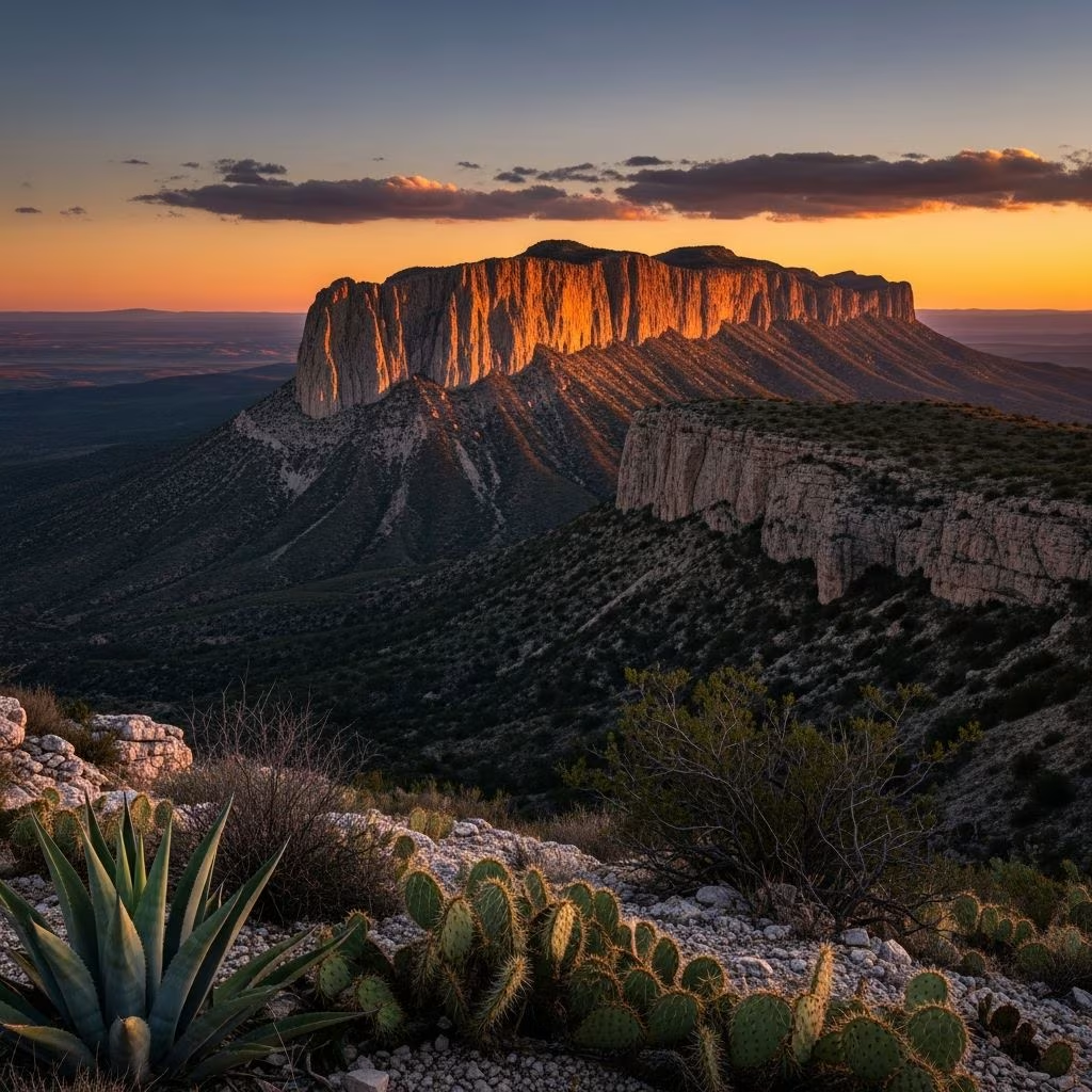
Nestled in the remote landscape of western Texas near the New Mexico border, Guadalupe Mountains National Park stands as one of America’s most underrated natural destinations. Home to Texas’s highest peak and an array of dramatic geological formations, this park offers visitors an unparalleled opportunity to experience pristine wilderness, ancient rock formations, and diverse ecosystems. With over 200,000 annual visitors, the park remains less crowded than many of its more famous counterparts, providing a more intimate connection with nature for those willing to venture off the beaten path.
Guadalupe Mountains National Park occupies a strategic position in far west Texas, situated approximately 110 miles east of El Paso, 56 miles southwest of Carlsbad, New Mexico, and 62 miles north of Van Horn, Texas. The park’s location on the edge of two time zones—Mountain and Central Standard Time—requires visitors to verify their device’s time settings upon arrival, as this geographical quirk can create confusion for those unfamiliar with the area.
The park’s distinctive geography encompasses five distinct administrative districts, each offering unique features and experiences. Pine Springs serves as the primary visitor hub and contains essential facilities. Salt Basin Dunes represents the far western section, featuring remarkable gypsum formations. McKittrick Canyon showcases a surprisingly lush riparian environment within the otherwise arid landscape. Frijole Ranch preserves historical structures and provides cultural context. Dog Canyon, accessible from the northeastern entrance, offers a more remote experience and alternative camping opportunities.
Accessing Guadalupe Mountains National Park requires advance planning, particularly regarding fuel and supplies. Travelers approaching from El Paso should take US-62/US-180 east for approximately 110 miles. Those coming from the east can access the park via Interstate 10, exiting at Exit 140 and following directional signage. Importantly, no gas stations operate between El Paso and the park, or between Carlsbad and the park entrance, necessitating a full fuel tank before departure.
Once inside the park, most scenic and recreational areas are accessible by personal vehicle along well-maintained roadways. Two principal roadside viewpoints merit stops during the approach: El Capitan Viewpoint and Guadalupe Park Viewpoint, both offering spectacular photographic opportunities and orientation to the surrounding landscape. The Pine Springs Visitor Center, the park’s primary information facility, provides maps, detailed trail information, and information regarding ranger-led educational programs.
The park experiences dramatic seasonal variations that significantly influence the visitor experience. Spring, spanning March through May, emerges as an ideal visiting period, characterized by moderate temperatures, blooming wildflowers, and comfortable hiking conditions. Similarly, fall months from September through November offer excellent conditions with pleasant weather and stunning visual displays as vegetation responds to cooling temperatures.
Summer temperatures in the park regularly exceed 90 degrees Fahrenheit, and the desert environment provides minimal natural cooling. Winter visits present their own challenges, with occasional snow at higher elevations and unpredictable weather patterns. Wind presents a consistent consideration regardless of season, with gusts occasionally exceeding 60 miles per hour, particularly at higher elevations and exposed ridges.
Guadalupe Mountains offers hiking experiences ranging from leisurely walks to strenuous alpine climbs. The Pinery Trail, paved and accessible to visitors with mobility considerations, provides historical context through the ruins of a mid-1800s Butterfield Stage Coach Station. This easy walk accommodates families and those seeking minimal physical exertion while still connecting with park history.
McKittrick Canyon Trail represents an intermediate option, stretching approximately 2.5 hours of hiking time through a surprisingly verdant canyon environment. The mostly flat terrain, interspersed with gentle elevation gains and occasional riverbed crossings, leads hikers through colorful rock walls and diverse plant communities. The trail culminates at the Grotto, a natural alcove providing scenic rest and reflection opportunities.
Devil’s Hall Trail offers moderate challenge with distinctive rewards. Rough footing, loose rocks, and occasional rock scrambling lead to two impressive natural rock formations, a stunning natural staircase, and a slot canyon configuration. The varied terrain and scrambling sections provide cardiovascular engagement without demanding elite fitness levels.
Guadalupe Peak Trail represents the park’s premier challenge. Rising 8,751 feet above sea level, Guadalupe Peak stands as Texas’s highest point and the destination for serious hikers. The approximately 9-mile roundtrip route gains over 3,000 feet of elevation, progressing from desert scrub through increasingly alpine vegetation before reaching an incredible summit ridge situated above the clouds. Weather volatility and wind exposure at higher elevations demand preparation, experience, and sound judgment regarding turnaround decisions.
The park operates two developed campgrounds accommodating overnight visitors. Pine Springs Campground, conveniently located near the principal visitor center and trailheads, offers the most accessible camping experience and serves as the typical starting point for Guadalupe Peak expeditions. Dog Canyon Campground, accessible from the northeastern approach, provides a more remote camping experience and represents the gateway to less-trafficked park areas.
Both campgrounds feature essential amenities including water availability and, at Pine Springs, proximity to visitor services. Reservations for campground sites are managed through Recreation.gov, requiring advance booking during peak seasons. Visitors should plan reservations at least several weeks ahead, particularly for spring and fall dates when weather conditions attract maximum visitation.
For those preferring conventional accommodations, nearby communities provide hotel options. Carlsbad, New Mexico, situated approximately 56 miles from the park entrance, offers the closest substantial lodging selection with varied price points and amenities. El Paso, while farther away at approximately 110 miles, provides additional options and diverse hospitality facilities serving the broader region.
Remote park location necessitates comprehensive supply planning. All food and provisions must accompany visitors, as no commercial establishments operate within or immediately adjacent to park boundaries. Water availability exists at the visitor center and campground facilities, reducing the carrying burden for day hikers, though backcountry travelers require water purification capabilities or carrying significant quantities.
Hiking-specific equipment enhances safety and enjoyment. Trekking poles prove particularly valuable on rocky, steep trails, providing stability on descent and reducing knee stress on challenging terrain. Appropriate footwear designed for rocky, uneven surfaces protects feet and ankles on trails featuring loose rocks and scrambling sections. Sun protection through high-SPF sunscreen, appropriate clothing layers, and protective eyewear address the intense desert sun and variable weather conditions.
Guadalupe Mountains possesses rich historical significance extending back centuries. The Mescalero and Lipan Apache peoples historically inhabited the region, developing sophisticated understanding of the challenging environment and seasonal resource availability. During the mid-1800s, the area became a critical waypoint along the Butterfield Overland Mail route, connecting the eastern United States with western territories. Surviving structures from this period, including the Butterfield Stage Coach Station ruins visible at the Pinery, provide tangible connection to this era.
The Holy Ranch History Museum, operated as a free facility, preserves additional historical documentation and artifacts reflecting the region’s development from indigenous occupation through European settlement and modern conservation efforts. The park officially achieved national park status in 1972, concluding a transition from private ownership and mining activities to its present role as a protected natural and cultural resource.
The park encompasses remarkable ecological diversity despite its arid location. Gypsum dunes in the western district support specialized plant communities adapted to mineral-rich soils. Douglas fir forests at higher elevations create surprising ecological zones within the generally desert environment. Desert plants, wildlife, and specialized plant communities reflect adaptation to extreme environmental conditions, including intense solar radiation, limited precipitation, and significant temperature fluctuations between seasons and between day and night.
Visitor centers, particularly the McKittrick Canyon facility, provide detailed information regarding local wildlife and plant communities, enabling visitors to develop deeper understanding of ecological relationships and the remarkable adaptations that support life in this challenging environment.
Successful park visits require attention to safety fundamentals. All hikers undertaking steep peak routes should check in at the nearest visitor center before departure, allowing staff to understand intended routes and enable rescue coordination if needed. Trail conditions change regularly, and wind speeds at exposed elevations warrant verification before committing to extended hikes. Visitors planning early departures should check conditions the preceding day, allowing adequate time to adjust plans if conditions prove unsuitable.
The park welcomes visitors for periods ranging from several hours to extended backcountry expeditions. Three-day visits allow comprehensive park exploration, visiting all five districts and experiencing diverse trail options. Longer visits—four or more days—enable more leisurely pacing, pursuit of more challenging routes like Hunter Peak via Bear Canyon or El Capitan Trail, and overnight backcountry experiences for those with appropriate skills and equipment.
Visitors with limited time should prioritize Pine Springs Visitor Center orientation, the Pinery historical site, and selection of one hiking option appropriate to available time and fitness level. Half-day visits might focus on the paved Pinery Trail combined with roadside viewpoint stops. Full-day visits accommodate intermediate trails like McKittrick Canyon or challenging routes like Devil’s Hall Trail. Multi-day visits enable comprehensive district exploration and ascent of Guadalupe Peak or other significant summits.
Spring (March–May) and fall (September–November) offer optimal conditions with moderate temperatures, comfortable hiking weather, and scenic beauty. Summer temperatures exceed 90 degrees Fahrenheit, while winter weather becomes unpredictable with occasional snow at higher elevations.
Most scenic and recreational areas are accessible by vehicle along maintained roadways. However, experiencing the park’s full wilderness character requires hiking, as many significant features lie beyond vehicular access.
Pets are permitted in specific areas including Pine Springs Campground and along the Paved Pinery Trail. However, pets are not allowed on most hiking trails, reflecting wildlife protection policies and visitor safety considerations.
Guadalupe Peak represents a strenuous undertaking with 3,000 feet of elevation gain over approximately 9 miles roundtrip. The hike demands moderate to advanced fitness levels, proper equipment, and careful attention to weather conditions.
On-site camping at Pine Springs and Dog Canyon campgrounds provides the closest overnight options. For hotel accommodations, Carlsbad, New Mexico (56 miles away), offers the nearest significant selection, with El Paso (110 miles) providing additional options.
