


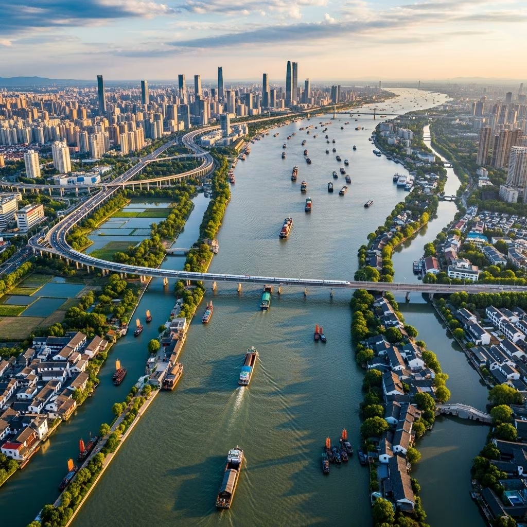
Understanding the Geography of Water-Dominated Landscapes
Jiangsu Province stands as one of China’s most distinctive regions, defined fundamentally by its relationship with water. Located on the east coast of China, this province presents a unique geographical profile that has profoundly influenced its development, culture, and economic trajectory throughout history. The terrain comprises predominantly flat alluvial plains, with approximately 68 percent of the province consisting of lowland areas, while water features occupy another 18 percent of the total surface area. This extraordinary flatness means that most of Jiangsu lies less than 50 meters above sea level, making it one of the lowest provinces in the country. The geographical composition creates an ideal environment for an intricate network of waterways that have become the defining characteristic of the region.
The formation of Jiangsu’s landscape resulted from millennia of fluvial processes involving multiple major river systems. The Yangtze, Huai, and historically the Huang River have deposited vast quantities of sediment across the region, creating the extensive lowlands that characterize modern Jiangsu. The Yangtze River delta in particular forms the central hub of this water-dominated landscape, with the Jiangnan plain situated south of the Yangtze lying at elevations of only 3 to 5 meters above sea level. This extraordinary combination of flatness and water availability created conditions that would eventually transform Jiangsu into one of China’s most economically significant regions.
The Ancient Waterway System and Its Economic Significance
Water has functioned as the lifeblood of Jiangsu’s economy for nearly two millennia, with the most significant waterway being the Grand Canal. This monumental engineering achievement, stretching more than 1,000 miles across northern and central China, was first completed during the Sui Dynasty between 581 and 618 AD. The original conception of the Grand Canal represented visionary urban planning, designed to facilitate the movement of grain and resources from the fertile Yangtze Delta regions northward to supply populations in drier areas like Beijing and the Huabei plain. This massive transportation system fundamentally restructured China’s economic geography, enabling unprecedented population expansion and concentration in previously marginal regions.
The Grand Canal’s historical importance cannot be overstated in the context of Jiangsu’s development. Cities including Suzhou and Yangzhou emerged as major commercial and cultural centers specifically because of their strategic positions along this waterway. The canal transformed these settlements from regional towns into metropolitan hubs that attracted merchants, artisans, and scholars from across the empire. The prosperity generated by canal commerce created a feedback loop of development, where accumulated wealth enabled investment in infrastructure, education, and cultural institutions that further enhanced these cities’ attractiveness as economic and intellectual centers.
Modern Water Infrastructure and Agricultural Development
Beyond the ancient Grand Canal, Jiangsu developed an extensive system of secondary waterways and irrigation channels that supported intensive agricultural production. The province constructed a sophisticated irrigation network that earned it the traditional designation of 水鄕 (shuǐxiāng), literally meaning “land of water” in English. The most significant of these modern irrigation projects includes the North Jiangsu Main Irrigation Canal, which channels water from the Huai River southward in channels paralleling the river’s historic course, ultimately directing water toward the sea. This engineering achievement demonstrates how communities adapted to Jiangsu’s distinctive hydrology, transforming a surplus of water in certain areas into a managed resource supporting agricultural productivity.
The irrigation systems represented more than mere technical accomplishments; they embodied sophisticated environmental management practices developed over centuries. Farmers throughout Jiangsu demonstrated remarkable knowledge of water distribution, soil management, and hydraulic engineering principles. The elaborate network of streams, canals, ponds, and lakes that crisscross the southern regions created what later observers would describe as an intricate hydraulic landscape, meticulously maintained by generations of cultivators. This managed waterscape supported some of China’s most productive agricultural regions, generating surpluses that fueled trade networks extending throughout Asia.
The Transformation of Coastal Wetlands in the Modern Era
During the early twentieth century, Jiangsu’s relationship with water entered a new phase through the activities of land reclamation companies. These privately-owned ventures, led by entrepreneurial figures such as Zhang Jian, undertook ambitious projects to transform coastal wetlands and saline marshlands into productive agricultural land. The companies engaged with global flows of knowledge and technology, integrating Japanese agricultural planning methods and Dutch hydraulic engineering techniques with indigenous Chinese practices. This cross-cultural technological exchange represented a significant moment in Jiangsu’s history, demonstrating how international expertise could be adapted to local conditions.
The reclamation process required substantial engineering effort and expertise. Companies constructed extensive dike systems to prevent seawater intrusion, implemented drainage networks to desalinate soils, and built irrigation channels to support cultivation. Initial reclamation efforts focused on planting salt-resistant vegetation such as reeds to gradually reduce soil salinity. After these preliminary measures rendered the land suitable for agriculture, companies transformed these formerly marginal territories into vast cotton plantations. The combined efforts of multiple companies resulted in the reclamation of approximately thirty-four square kilometers of land through projects such as the Yaowang Harbor Sluice, demonstrating the scale and sophistication of these enterprises.
Contemporary Water Management and Environmental Challenges
Modern Jiangsu faces a different water-related challenge than its ancestors: balancing economic development with environmental protection and sustainable resource management. The province contains more than 200 freshwater lakes of varying sizes, accounting for approximately 6 percent of its total area. Five particularly significant lakes—Taihu, Gehu, Gaobaoshaobo, Hongze, and Luoma—serve as crucial water resources for both agricultural and municipal purposes. However, rapid industrialization and urbanization have stressed these aquatic systems, leading to surface shrinkage, increased pollution loads, declining water quality, and ecosystem degradation.
The challenges became acute in 2007 when algal blooms contaminated major freshwater sources, forcing emergency shutdowns of municipal water supply systems in affected cities. The crisis prompted authorities to rely on alternative groundwater sources, which resulted in aquifer depletion and saltwater intrusion in coastal areas—ironically recreating challenges similar to those faced by early twentieth-century reclamation companies. These contemporary challenges underscore how Jiangsu’s relationship with water remains complex and demanding, requiring ongoing technological and policy innovation.
Recognizing these challenges, the Jiangsu provincial government launched comprehensive water management initiatives. The Jiangsu Water and Wastewater Project targeted improvements in water quality for surface water sources including lakes, rivers, and canals. The project incorporated multiple strategic components: expanding municipal water supply infrastructure, implementing integrated urban and rural water supply planning, and building institutional and financial capacity for long-term sustainability. Provincial environmental protection authorities coordinated multidimensional pollution control efforts across point sources, linear systems, and area-wide approaches. These comprehensive interventions have enabled Jiangsu’s freshwater lakes to meet both national fishery water quality standards and drinking water quality requirements.
Cultural Heritage and Water-Centered Communities
Jiangsu’s water systems generated not only economic prosperity but also distinctive cultural expressions centered around aquatic environments. The region’s canal cities, particularly Suzhou, earned international recognition as manifestations of water-based urban design and aesthetic philosophy. These communities developed unique architectural styles, agricultural practices, and social organizations adapted to their waterlogged environments. The harmony between water and human activity created landscapes of exceptional cultural and aesthetic significance, attracting scholars, artists, and visitors for centuries.
The idyllic water towns scattered throughout southern Jiangsu represent enduring symbols of this water-centered culture. These settlements preserve traditional building styles, narrow canal-side streets, and bridge systems that reflect centuries of adaptation to aquatic environments. The communities represent living museums of how human societies can develop sophisticated, sustainable relationships with abundant water resources, offering contemporary insights into integrated water management and sustainable urban planning.
Economic and Strategic Importance in Contemporary China
Contemporary Jiangsu has evolved into one of China’s leading economic regions, with its prosperity firmly rooted in the historical advantages provided by its water systems. The province ranks among China’s most advanced in finance, education, technology, and tourism sectors. The Yangtze River delta region, which encompasses much of Jiangsu, continues to function as one of the world’s most dynamic economic zones, generating enormous wealth through manufacturing, services, and international trade.
The strategic positioning along the lower Yangtze River—Asia’s longest river completing its 4,000-mile journey from the Qinghai-Tibet plateau to the East China Sea—continues to provide competitive advantages for modern commerce. Contemporary container ships navigate these ancient waterways, maintaining the region’s role as a crucial link in global supply chains. The integration of traditional water infrastructure with modern transportation networks demonstrates how Jiangsu’s geographical advantages continue to support economic development in the twenty-first century.
Frequently Asked Questions
What does “land of water” mean in the context of Jiangsu Province?
The designation 水鄉 (shuǐxiāng) refers to Jiangsu’s distinctive geography featuring extensive waterways, irrigation systems, lakes, and canals that cover approximately 18 percent of the province’s surface area. This term reflects how water fundamentally shapes the region’s landscape, economy, culture, and identity.
How did the Grand Canal transform Jiangsu’s economy?
The Grand Canal, completed in 581-618 AD, enabled efficient transportation of grain and resources from the fertile Yangtze Delta to northern China. This connectivity catalyzed the emergence of major trading cities like Suzhou and Yangzhou, attracting commerce, merchants, and talent that generated sustained prosperity and urban development.
What environmental challenges does Jiangsu face regarding water management?
Rapid industrialization and urbanization have caused lake surface shrinkage, increased pollution loads, and ecosystem degradation. Particularly, 2007 algal blooms contaminated major water sources, forcing emergency water supply shutdowns and leading to groundwater over-extraction and coastal saltwater intrusion.
How did early twentieth-century reclamation projects transform Jiangsu’s coastline?
Land reclamation companies employed Dutch hydraulic engineering and Japanese agricultural techniques to transform saline coastal wetlands into productive cotton plantations. These projects reclaimed approximately thirty-four square kilometers through dike construction, soil desalination, and irrigation infrastructure.
Why is Suzhou called the “Venice of the East”?
Suzhou earned this designation because of its distinctive urban design centered around canals, bridges, and waterways that echo Venice’s water-based architecture. The city’s strategic location along the Grand Canal and its network of connecting waterways created an aesthetic and functional environment unparalleled in Chinese cities.
Key Characteristics of Jiangsu’s Water Systems
| Feature | Characteristics | Historical Significance |
|---|---|---|
| Elevation | Less than 50 meters above sea level; most areas 3-5 meters | Enabled water accumulation and irrigation farming |
| Water Coverage | Approximately 18% of provincial area | Supported transportation and trade networks |
| Grand Canal | Over 1,000 miles; completed Sui Dynasty (581-618 AD) | Connected north and south; enabled economic integration |
| Major Lakes | Over 200 freshwater lakes; includes Taihu, Hongze, Gehu | Support agriculture, industry, and municipal water supply |
| River Systems | Yangtze, Huai rivers shape landscape and commerce | Created fertile deltas; enabled food production surplus |
Conclusion: Water as Foundation of Prosperity
Jiangsu Province exemplifies how geographical features, technological innovation, and cultural adaptation can combine to create enduring prosperity. For nearly two thousand years, water has functioned as both challenge and opportunity for the region’s inhabitants. From the engineering of the Grand Canal to modern wastewater management systems, each generation has developed sophisticated responses to living in and benefiting from this water-dominated landscape. The province’s continued status as one of China’s most economically advanced regions testifies to how effectively communities can harness their distinctive environmental characteristics for sustained development. As Jiangsu navigates contemporary challenges of environmental protection and sustainable resource management, its historical experience with water infrastructure offers valuable lessons for balancing economic growth with ecological stewardship.
References
- Jiangsu — Wikipedia. Accessed April 2026. https://en.wikipedia.org/wiki/Jiangsu
- Jiangsu: History, Culture & Economy of China — Britannica. https://www.britannica.com/place/Jiangsu
- Jiangsu Province: Welcome to the Land of Water — Lonely Planet. https://www.lonelyplanet.com/articles/jiangsu-province-land-of-water
- Trends and Causes of Raw Water Quality Indicators in the Five Most Polluted Freshwater Lakes of Jiangsu Province, China — National Center for Biotechnology Information (NCBI/PMC). 2022. https://pmc.ncbi.nlm.nih.gov/articles/PMC8834795/
- Spatial Transformation and Water Infrastructure in Coastal Jiangsu — Journal of Historical Geography. 2025. https://www.tandfonline.com/doi/full/10.1080/02665433.2025.2525515
- China: Advancing Water and Wastewater Services in Jiangsu Province — World Bank. February 26, 2018. https://www.worldbank.org/en/results/2018/02/26/china-advancing-water-and-wastewater-services-in-jiangsu-province

