

 Travel Essentials
 Travel Essentials

Explore Mt. Aso's massive caldera, active craters, cascading waterfalls, hot springs, and cultural practices like controlled grassland burns in Japan's Kyushu region.
 Travel Essentials
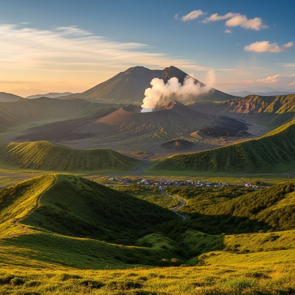
Japan’s Kyushu island hosts one of the planet’s most dynamic natural spectacles at **Mt. Aso**, a sprawling volcanic system where raw geological power continues to sculpt the terrain. This active volcano complex, centered in Kumamoto Prefecture, features the world’s largest caldera and draws adventurers with its blend of fiery craters, verdant grasslands, and life-sustaining waters.
The foundation of Mt. Aso lies in cataclysmic events from 90,000 to 270,000 years ago, when massive eruptions hurled ash across vast distances, depositing layers up to 10 cm thick even in distant Hokkaido. This led to the collapse of the volcano, forming a colossal caldera spanning 18 km east-west and 25 km north-south—one of the largest on Earth.
Today, this basin cradles fertile plains, small towns, and agricultural fields, a testament to nature’s resilience. The caldera floor, once periodically a vast lake, now supports everyday life amid reminders of its volatile past. Porous volcanic soil here acts as Kyushu’s vital aquifer, filtering rainwater into pure, mineral-laden sources that supply millions.
At the heart of Aso Gogaku (the official name for the Aso peaks) stands Nakadake, the most prominent crater, perpetually venting white smoke and surrounded by molten rocks. Accessible via toll roads and cable cars, the summit offers breathtaking views into the steaming abyss, though access is often restricted due to eruptions—over 38 recorded since 1950.
Visitors can witness the raw energy of the Pacific Ring of Fire here, with Japan boasting over 100 volcanoes. Despite risks, like the 2014-2015 activity that drifted ash southward, the site remains a top draw for those seeking Japan’s geological drama.
| Crater Feature | Description | Visitor Notes |
|---|---|---|
| Nakadake Crater | Active vent with smoke and lava views | Cable car access; frequent closures |
| Surrounding Cones | Cinder cones within caldera | Hiking trails when safe |
| Sulfur Deposits | Yellow landscapes near vents | Strong odors; protective gear advised |
Contrasting the fire, Mt. Aso’s northern reaches boast waterfalls born from ancient lava flows. **Nabegataki Falls** impresses as a 20-meter-wide curtain of water tumbling 10 meters over solidified lava remnants, creating a misty veil perfect for photography.
Close by, **Shimonjo Falls** channels a slender stream 30 meters into a basalt-columned gorge, evidence of rapid lava cooling. Upstream, **Nabekama Falls** features turbulent rapids carving potholes into the resistant bedrock, offering serene spots for reflection amid the rush.
These sites, near Oguni town on 90,000-year-old pyroclastic deposits, highlight water’s erosive dance with volcanic rock, forming accessible natural wonders.
Aso’s expansive grasslands, vital for cattle grazing, owe their persistence to **noyaki**—controlled burns practiced for over 1,000 years. Each spring, locals ignite dry grasses to prevent shrub encroachment, enrich soil with ash nutrients, and sustain biodiversity.
Participants wield hikeshi-bou (bamboo beaters) and backpack water cannons to manage flames, coordinating via radio to ensure fires meet precisely at field centers. This ritual not only preserves pastures but fosters community bonds and unique ecosystems.
Mt. Aso’s volcanic heat fuels abundant **onsen** (hot springs), bubbling across the landscape. These mineral-rich waters, drawn from the caldera’s depths, offer relaxation amid steaming pools and riverside baths, a hallmark of Japanese wellness traditions.
Popular spots include facilities near the grasslands and craters, where visitors soak while gazing at the volcanic backdrop. The springs’ purity stems from the same underground reserves nourishing Kyushu, blending therapy with the mountain’s elemental forces.
Part of **Aso-Kuju National Park**, Mt. Aso welcomes hikers, cyclists, and drivers. Base yourself in Aso town for crater access or Oguni for waterfalls. Trains and buses connect from Kumamoto City; rentals enhance flexibility across the vast caldera.
Best Times to Visit: Spring for noyaki and cherry blossoms; autumn for mild weather and foliage. Monitor Japan Meteorological Agency alerts for summit status.
| Activity | Duration | Difficulty |
|---|---|---|
| Crater Hike | 1-2 hours | Moderate |
| Waterfall Trail | 2-3 hours | Easy |
| Noyaki Observation | Half-day | Observer |
| Onsen Soak | 1 hour+ | Relaxing |
Beyond nature, Mt. Aso pulses with traditions tied to its deities. Fire festivals and harvest rites honor volcanic spirits, while farms thrive on grassland yields. Towns like Aso blend modern amenities with ancient practices, offering farm stays and local cuisine featuring Aso beef.
The mountain’s dual nature—destructive yet nurturing—mirrors Japan’s harmony with peril, where communities adapt through rituals and resilience.
Yes, with precautions. Check official alerts; craters close during high activity, but surrounding areas remain open.
Mt. Aso’s holds that title, measuring 25×18 km.
Spring annually; dates vary by weather and coordination.
Yes, from ryokans with onsen to campsites in the national park.
By JR train (1-2 hours) or bus; car rentals recommended for flexibility.
Efforts to balance tourism with conservation include trail maintenance and eruption monitoring. Visitors contribute by following rules, supporting local economies, and respecting the fragile balance of fire and water that defines this iconic site.
