

 Travel Essentials
 Travel Essentials

Comprehensive guide to hiking the Tongariro Alpine Crossing: trail stats, preparation tips, section breakdowns, weather advice, and logistics for this world-famous 19.4km trek in Tongariro National Park.
 Travel Essentials
Embark on one of the world’s most celebrated day hikes through New Zealand’s Tongariro National Park, a UNESCO Dual World Heritage site blending cultural significance and raw volcanic beauty. This 19.4 km point-to-point adventure challenges hikers with steep ascents, otherworldly craters, and shimmering alpine lakes, typically taking 6-8 hours to complete.
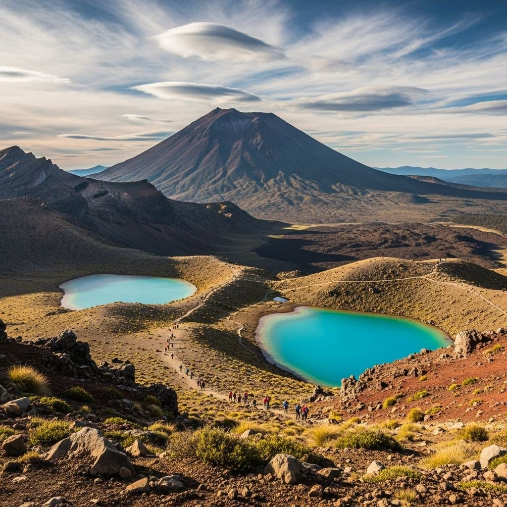
The Tongariro Alpine Crossing earns its reputation as New Zealand’s finest single-day hike and ranks among the top ten worldwide, drawing adventurers to its active volcanic terrain in the North Island’s Tongariro National Park—the country’s oldest protected area established in 1887. Hikers traverse dramatic lava flows, ascend the notorious Devil’s Staircase, and gaze into Red Crater’s vivid hues, with potential side trips to Mount Ngauruhoe, famously Mount Doom from The Lord of the Rings. On clear days, panoramic views stretch to Lake Taupō and distant peaks, while the descent weaves through fern-filled forests and past cascading waterfalls.
What sets it apart is the dynamic landscape: from barren moonscapes to geothermal springs, embodying the park’s living geology. Dual UNESCO status recognizes both its natural volcanoes and Maori cultural heritage, gifted to New Zealand by Ngāti Tuwharetoa in 1887 for perpetual protection. Expect a strenuous workout with 700-800m elevation gain and over 1,100m loss, demanding fitness and preparation.
| Attribute | Details |
|---|---|
| Distance | 19.4 km (12 miles) point-to-point |
| Elevation Gain | 736-765m (2,100-2,500 ft) |
| Elevation Loss | 1,125-1,236m (3,700-4,050 ft) |
| Duration | 6-8 hours (experienced hikers 5-7 hours) |
| Difficulty | Strenuous/Advanced (steep climbs, exposed sections) |
| Best Direction | Mangatepopo to Ketetahi (climbs first, descends later) |
Data compiled from multiple hiker reports confirms consistent metrics, though exact gains vary slightly by measurement. Rated hard due to relentless uphill to 1,900m, loose scree, and weather exposure; not suitable for beginners or those with altitude/ knee issues.
Start at Mangatepopo Trailhead (lower parking limited to 4 hours) and finish at Ketetahi Trailhead, 11km apart—shuttles are mandatory for point-to-point. Book in advance via operators like those in Taupō or National Park Village; costs NZ$30-50 one-way, departing 6-7 AM to beat crowds. Driving? Park at Ketetahi (secure) and shuttle to start, or use hotel pickups.
Public transport sparse; guided tours (NZ$150+) include gear and expertise for novices.
Tongariro’s alpine microclimates shift rapidly—clear starts can turn to blizzards, winds exceed 100km/h, visibility drops to zero. Monitor MetService forecasts 48 hours ahead; hut webcams provide real-time views. Key rule: If unsure, don’t go—fatalities occur yearly from exposure.
Park rangers emphasize: Conditions at trailhead differ vastly from ridge (1,000m higher).
Layers are non-negotiable for 0-25°C swings. Pack light (under 10kg) but comprehensively.
| Category | Must-Haves |
|---|---|
| Clothing | Merino base layers, fleece mid, waterproof jacket/pants, thermal hat/gloves, sun hat, 2-3 pairs socks |
| Footwear | Ankle-supporting boots with grip (no sneakers), gaiters for scree |
| Protection | Sunscreen (SPF50+), sunglasses, lip balm |
| Essentials | 2L+ water, high-energy snacks (nuts, bars, chocolate), first-aid (blister kit, painkillers), map/app (offline), power bank, whistle |
| Optional | Poles for knees, hand warmers, headlamp (delays) |
Toilets at start, Soda Springs (1.5hrs), Ketetahi Hut (4-5hrs), near end. No rubbish bins—carry out all waste.
Divide into phases for pacing; signs provide km/toilet markers.
Wide, rolling path through tussock and scoria; steady inclines warm muscles. Pass toilets (0.7 miles), spot Ngauruhoe looming. Reach geothermal Soda Springs—steaming vents signal volcanic heart.
The crux: 500+ relentless steps on loose gravel to South Crater rim. Pole-assisted zigzags ease quads; pause for Mt. Tongariro views. High point at 1,900m—exposed, windy.
Flat moon-like South Crater, then steep scramble to Red Crater’s sulfur-stained edges—stunning emerald Central Crater below. Optional Ngauruhoe sidetrip (2-3hrs extra, 800m gain).
Switchbacks past Blue Lake views yield to knee-pounding scree chutes, then staircases and forest boardwalks. Final waterfall detour delights; emerge at Ketetahi parking.
Aim for 10km hikes with 500m gain weekly pre-trip. Stair climbs, lunges build staircase endurance; interval cardio for altitude. Test full pack on similar terrain. Rest knees post-hike with ice/compression.
Tread lightly on fragile alpine zones; stick to track to avoid erosion. No drones, pets, or shortcuts. Emergencies: PLB if solo, group stays together. Volcano alerts (Mt. Tongariro/Ngauruhoe active)—evacuate if yellow/red.
Shoulder seasons (Oct-Nov, Mar-May) balance weather/crowds. Sunrise starts evade 1,000+ summer hikers. Extend with Tongariro Summit (advanced) or Taranaki Falls loop. Nearby: Taupō hot springs, Hobbiton tours.
Possible with crampons/ice axe, but often closed; guided only recommended.
For fit teens+; under 12s or poor fitness should opt for shorter trails.
Retreat to nearest hut (Soda Springs/Ketetahi); shuttles may rescue.
No, but track fees possible; conservation voluntary.
Pack your own; Taupō has pre-hike eateries.
This trek rewards preparation with transformative views and achievement. Plan meticulously for an unforgettable volcanic odyssey.
